Forecast for Central Texas

 0%20%
0%20% 70%40%
 0%
0%
Reports from LCRA’s Hydromet
Rainfall summaryTemperature summary
Humidity summary
Bob's Blog on Central Texas Weather
Widespread Rain and Thunderstorms Expected Sunday into Monday
Severe storms spread southeast across the eastern Hill Country, from Enchanted Rock, through Johnson City, to San Marcos Thursday evening. Another area of severe storms tracked from eastern Williamson County through Lee County. These damaging storms produced very large hail of generally 1 to 3 inches in diameter. The largest hail appears to have fallen in and around Johnson City, in Blanco County, where 4 to 5 inch diameter hail was observed. The National Weather Service is confirming one of the hail stones in Johnson City measured 6.25 inches in diameter! This is just shy of the Texas record for largest hail stone which fell near Hondo in April, 2021. That stone measured 6.42 inches in diameter.
Quiet and more stable weather has developed across the region following the passage of a weak cold front late Thursday night. The air behind the front is noticeably drier and just slightly cooler. Another benefit to the front is that is has pushed out the haze and smoke that’s plagued our area throughout the week.
Friday’s weather will include a mostly sunny to partly cloudy sky and less hot temperatures. Dry weather is forecast at most locations. However, there will be a 20-30 percent chance for a few scattered showers and thunderstorms across the region as a weak wave of low pressure pushes northeast over the area. The threat for any of these storms being severe will be quite low.
- Friday’s high temperature will range from the upper 70s across the northern Hill Country, to low 80s across Central Texas, to the mid and upper 80s near the coast.
- Lows Saturday morning will include the low 60s across the Hill Country, the low and mid-60s across Central Texas, and the upper 60s across the coastal plains.
A change in the weather is predicted to take place Saturday as trough of low pressure begins to push east out of the Arizona and New Mexico. Moisture is forecast to begin retuning off the Gulf of Mexico Saturday ahead of the upper trough. Expect a partly to mostly cloudy sky throughout the day. There will be a slight chance for a few scattered showers and isolated thunderstorms beginning Saturday afternoon, continuing through Saturday evening. Chances for any severe storms looks to be quite low.
Atmospheric conditions across the Hill Country, Central Texas, and the middle Texas coast ahead of the approaching trough are shaping to be quite favorable for the development of waves of rain showers and scattered thunderstorms beginning around midnight Saturday night, continuing through Sunday and Sunday night. The probability for rain will be near 80 percent. Some of the ingredients for severe thunderstorms will also be in place. The Storm Prediction Center has placed the entire region under a Marginal Risk, or 1 out of 5 risk, for severe thunderstorms. The primary severe weather threats will be large hail and damaging winds.
The waves of rain and thunderstorms are forecast to continue into Monday, then slowly taper off from west to east Monday afternoon as the upper trough exits our region. A weak cold front moving through the area Monday afternoon will bring in drier and slightly cooler air.
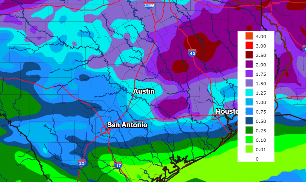
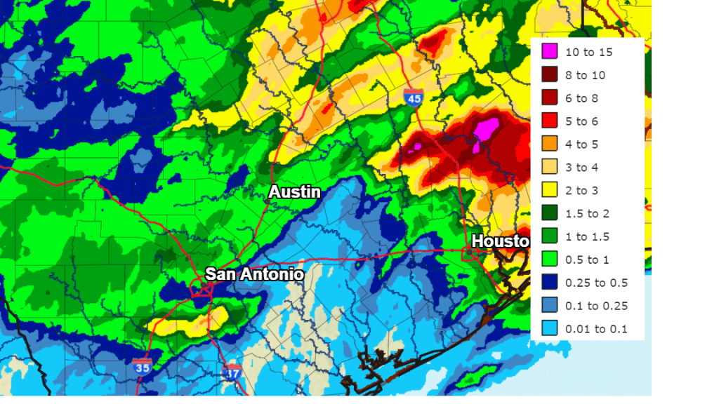
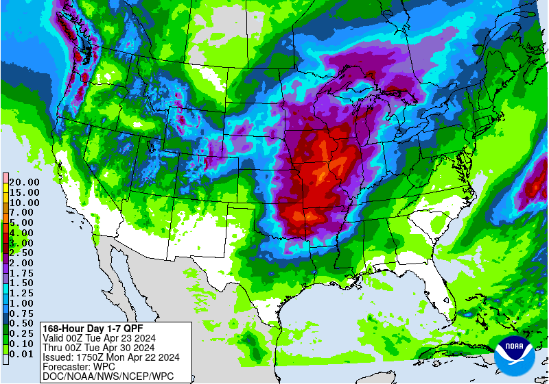
Rain amounts from Saturday night through Tuesday morning are forecast to generally average around an inch across the Hill Country, and between 1 and 2 inches at most other locations.
NWS Rainfall Forecast Valid from 7 pm Friday through 7 pm Monday:
Clouds are forecast to clear Monday night. This will be followed by a mostly sunny sky on Tuesday.
- Highs Sunday are forecast to be in the upper 70s to low 80s.
- Highs Monday are forecast to be in the mid and upper 80s.
- Highs Tuesday are predicted to be in the upper 80s.
A chance for rain and scattered thunderstorms looks to return to the forecast next Wednesday and Thursday when a trough of low pressure dips south out of the southern Plains and moves across North Texas. The atmospheric setup with the approaching trough is looking somewhat favorable for the development of strong to severe thunderstorms across the Hill Country and parts of Central Texas both days. Rain amounts for both days are forecast to generally average between 1 and 1.5 inches.
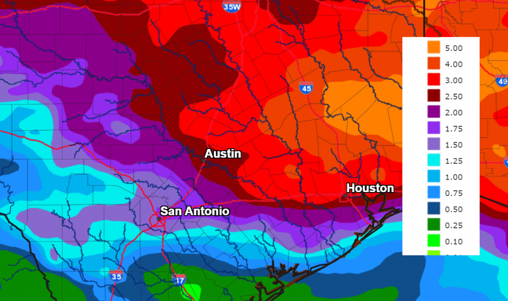
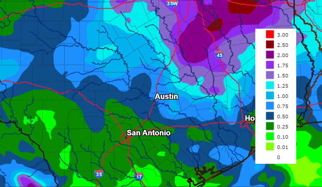
Adding the forecast rainfall early in the week with the rain forecast Wednesday and Thursday, amounts of 1-2 inches are forecast across the Hill Country, with 2-4 inch totals at most other locations.
NWS Rainfall Forecast for the Period 7 pm Friday through 7 pm Next Friday:
A dry and warmer weather pattern is forecast to develop next Friday when a ridge of high pressure builds north out of Mexico. This pattern is predicted to continue next weekend and into the following week. Expect daily high temperatures to be in the low 90s.
Wishing everyone a Happy Mother’s Day Weekend.
Bob
Previous Blog Entries
Turning Much Warmer Tuesday and Wednesday. Cooler Late Week and into the Weekend
Rounds of rain showers and thunderstorms since the middle of last week caused significant totals of rain across the Hill Country and Central Texas regions. According to LCRA’s Hydromet, the highest totals over the past 5 days occurred across the northern Hill Country across Mills, Lampasas, San Saba, and McCulloch Counties where amounts of 5-8 inches were recorded. Much of the region received between 1 and 2 inches of rain, with isolated totals of 3-4 inches. Interestingly, the heavy rains missed the middle Texas coast. Across Wharton and Matagorda Counties, totals over the past 5 days have only averaged around a quarter inch or less.
NWS Estimate of Rain Falling between 7 am Wednesday and 7 am Monday:
Data Courtesy NWS West Gulf River Forecast Center
The large trough of low pressure responsible for the recent stretch of wet and stormy weather across much of Texas has pushed off to the northeast. While this system has moved out, the base of a second trough of low pressure is currently moving from the Texas Panhandle region into the southern and central Plains states. This system will draw considerable clouds and moisture north from the Gulf of Mexico, resulting in a mostly cloudy sky Monday afternoon through Monday night. This system may generate a few widely scattered rain showers or isolated thunderstorms across the region Monday afternoon, but no significant rain is expected. Monday’s temperature is forecast to warm to the low and mid-80s. Lows Tuesday morning will are forecast to be in the upper 60s to low 70s.
A dry and warmer weather pattern is forecast for Tuesday and Wednesday as a ridge of high pressure temporarily spreads north across Texas out of Mexico. Widespread low clouds Tuesday and Wednesday mornings will give way to mostly sunny conditions both afternoons. This ridge is expected to bring unseasonably warm temperatures to the entire region.
- High temperatures Tuesday are forecast to be in the upper 80s across the Hill Country, and in the low 90s across Central Texas and the coastal region.
- High temperatures Wednesday are forecast to be in the low 90s region-wide.
- Lows Wednesday and Thursday mornings will generally be in the low 70s.
Due note: with the wet ground and a moist flow off the Gulf, afternoon heat index readings across the region may approach 100-108 degrees Tuesday and Wednesday.
A change in the weather is forecast to take place Thursday when a fairly strong cold front (for May standards) pushes south out of North Texas. Moisture convergence along the front is expected to cause the development of a few scattered rain showers and thunderstorms along the cold front. The probability for rain will only be near 20-30 percent. Forecasts call for rain amounts to average less than a quarter inch, with most areas remaining dry. Expect a partly to mostly cloudy sky Thursday and mostly sunny sky Friday through Saturday. The front will bring somewhat cooler air into the area Thursday through Friday.
- High temperatures Thursday will include the low 80s across the Hill Country, the mid-80s across Central Texas, and the low 90s across the coastal plains.
- Lows Friday and Saturday mornings will include the upper 50s to 60 degrees across the Hill Country, the low 60s across Central Texas, and the mid to upper 60s coastal plains.
- High temperatures Friday are forecast to be in the upper 70s across the Hill Country and Central Texas, and in the low 80s across the coastal plains.
- High temperatures Saturday are predicted to be around 80-82 degrees.
A chance for rain showers and scattered thunderstorms will return the outlook for Sunday, and this chance for rain looks to continue through most of next week. Forecasts call for a broad trough of low pressure to develop across the Desert Southwest on Sunday, with the trough then lingering over the area into early next week. The trough is forecast to sink south into Mexico and approach Texas through the second half of next week. Moisture spreading north from the Gulf will cause a 30-40 percent chance for scattered rains across the area Sunday through Tuesday, with an even higher chance for rain expected next Wednesday through Friday, possibly continuing into the following weekend as well. This forecast solutions are still trying to sort this picture out, but the overall pattern is looking wet and unsettled.
High temperatures next week are forecast to generally be in the mid-80s.
Bob
Rounds of Rain and Strong to Severe Storms Will Continue through the Weekend
Key Messages:
- A wet and unsettled weather pattern will continue through the weekend
- Thunderstorms developing across West Texas Friday afternoon may spread east across parts of the Hill Country and Central Texas Friday evening and Friday Night
- Some of these storms could produce large hail and damaging winds
- Confidence is increasing in more widespread, impactful rain and thunderstorms to spread southeast into the northern half of the Hill Country and Central Texas late Saturday afternoon and Saturday night
- Late hail, damaging winds, and moderate to heavy rain will be possible
- Periods of showers and scattered thunderstorms are forecast across the entire region through Sunday afternoon
- A generally dry weather pattern is forecast to take hold on Monday
Discussion
An active and potentially stormy weather pattern is expected to continue trough the weekend.
There will be a 20-30 percent chance for some widely scattered rain showers and isolated thunderstorms across the region Friday afternoon. Expect high temperatures to generally be in the low and mid-80s.
Forecasters will be keeping a close watch across West Texas late this afternoon as atmospheric conditions will be favorable for thunderstorms to develop along the West Texas dry line. Scattered thunderstorms are forecast to develop and quickly become severe over the area from southeast of Lubbock, to west of San Angelo, to near Del Rio. Storm Prediction Center forecasters state these storms will have the potential to produce large to giant size hail (max size 3-4+ inches in diameter), a few tornadoes, and severe wind gusts across the Texas South Plains extending southeastward into portions of the Big Country Friday evening.
High resolution forecasts call for the area of storms to spread east across the Edwards Plateau and Hill Country regions Friday evening. Some of the storms could even reach the Austin and Interstate 35 corridor sometime late Friday evening and toward midnight. The primary severe weather threats will primarily be large hail, damaging downburst winds, and locally heavy rain. The thunderstorms activity is expected to diminish shortly after midnight.
The Storm Prediction Center has placed the Hill Country under a Slight Risk, or 2 out of 5 risk, for severe thunderstorms through Friday Night. The Intestate 35 corridor has been placed under a 1 out 5 risk for severe thunderstorms.
Rainfall from Friday evening’s storms developing storms is forecast to average between 0.5 and 1 inch, with isolated totals of 1-2 inches possible.
Saturday
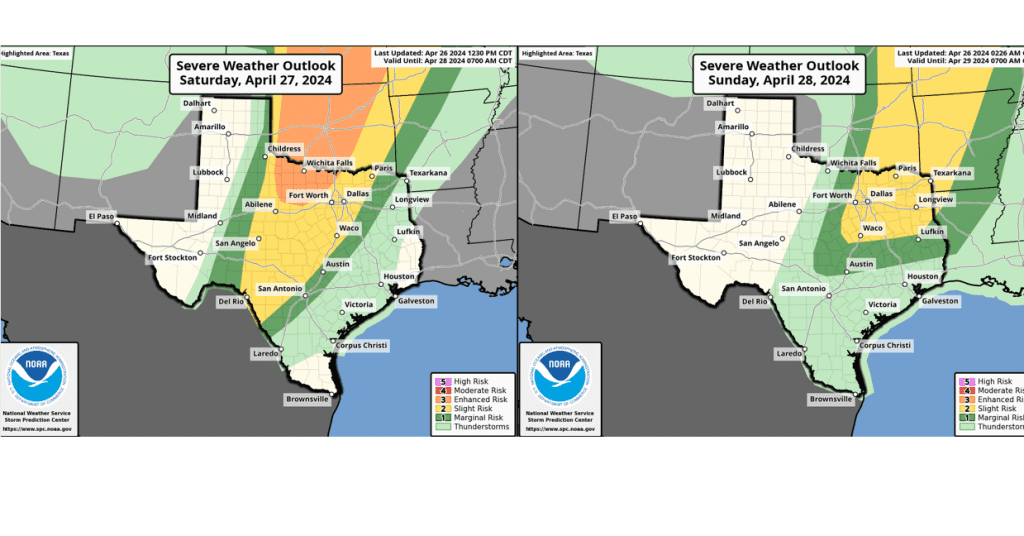
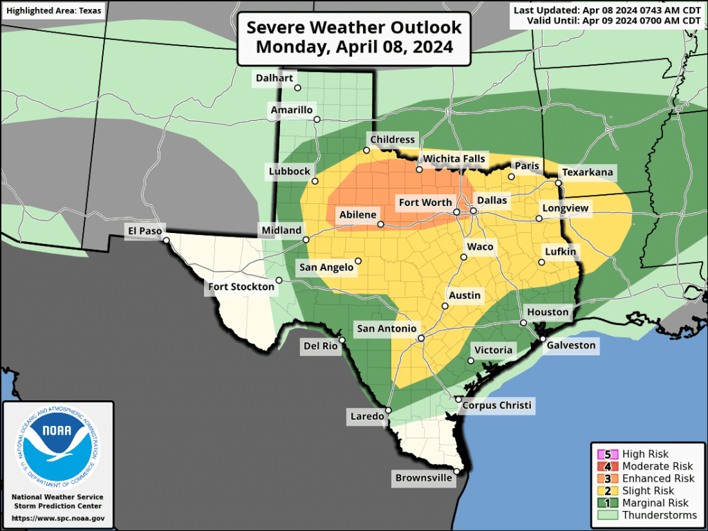
Several of the forecast solutions are keying in on a trough of low pressure that will be moving into West Texas Saturday afternoon. The solutions call for a large area of rain showers and thunderstorms to develop across Northwest and West Central West Texas Saturday afternoon. This activity is then predicted to spread east-southeast across the northern half of the Hill Country and the northern half of Central Texas, including the Austin area, Saturday evening. Some of the rain and storms may spread further south into the Hill Country and Central Texas late Saturday evening into Saturday night. Once again, some of these storms could be severe, with the primary severe weather threats being large hail, damaging winds and locally heavy rain. The Storm Prediction Center has placed the Hill Country and the I-35 corridor under a Marginal, or 1 out or 5 risk, for severe storms through Saturday night. (See the severe weather outlook map for Saturday above)
Rain amounts Saturday through Sunday morning are forecast to generally average between 1 and 2 inches across the northern half of the Hill Country and Central Texas. For areas to the south, totals of around a half inch are forecast.
Sunday
Forecasts call for additional waves of rain showers and scattered thunderstorms to spread across the region Sunday morning through Sunday afternoon. The probability for rain will be near 50-60 percent. Expect rain amounts to average between 0.25 and 0.5 inches. The rain and thunderstorms are forecast to taper off Sunday evening.
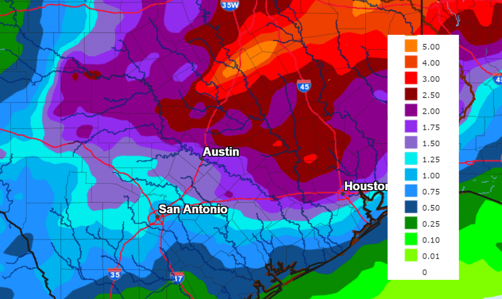
Rain amounts between Friday evening and Monday evening are forecast to average between 1 and 4 inches across the northern Hill Country, and between 1 and 2 inches for the northern counties of Central Texas, including Austin. For areas to the south, rain amounts will average between 0.25 and 1 inch.
NWS Rainfall Forecast for the Period 7 pm Friday through 7 pm Monday:
Next Week
The recent wet weather pattern is predicted to diminish by Monday as a ridge of high pressure spreads over Texas out of Mexico. A partly to mostly cloudy sky is forecast Monday. Tuesday through Thursday will see a mostly sunny sky. High temperatures next Tuesday through Thursday are forecast to generally be in the low to mid-90s. Highs are forecast to lower back to the mid-90s next Friday when a “cold” front sinks south across the area.
Bob
Severe Storms and Heavy Rain Possible Wednesday Afternoon and Wednesday Night
Key Messages
- Isolated to scattered strong to severe storms will be possible across the region this afternoon through tonight
- Large hail (possibly greater than 2 inches in diameter) and damaging winds will be the primary severe weather threats
- There will be a low end chance for a couple of isolated tornadoes
- Locally heavy rainfall and flooding possible—primarily across the eastern Hill Country and Central Texas regions. Here, widespread totals of 1-3 inches are forecast, with isolated totals of 3-5 inches possible
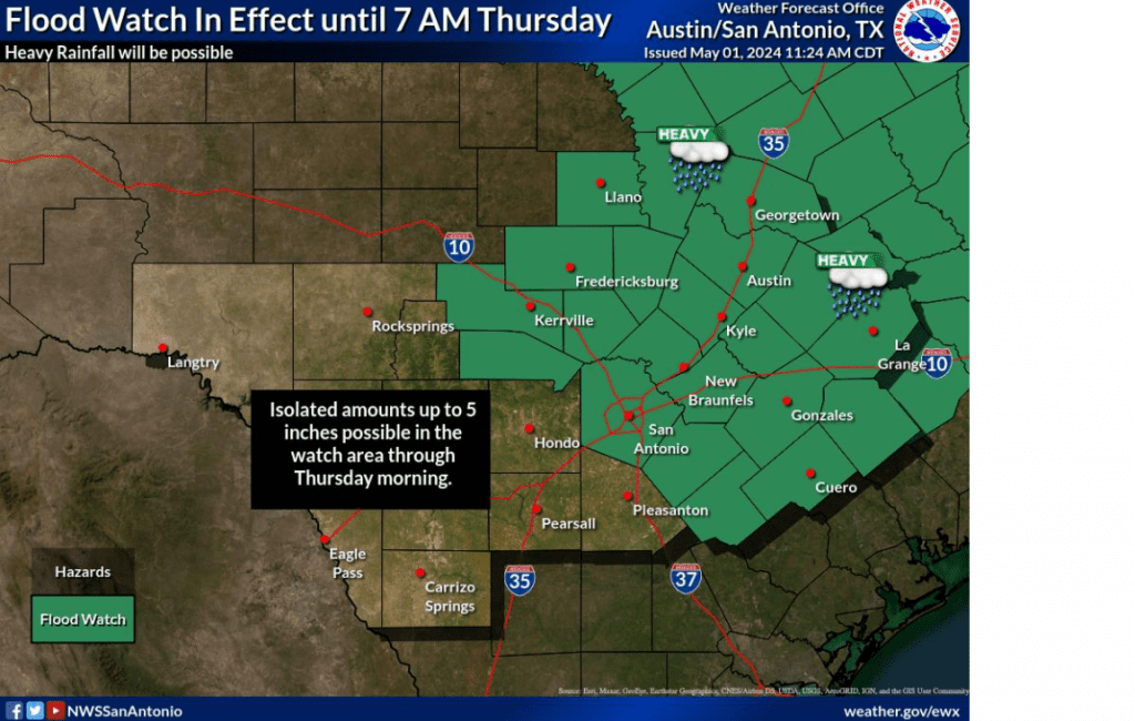
- The National Weather Service has posted a Flood Watch for the eastern Hill Country and all of Central Texas from 3 pm Wednesday through Thursday morning
Discussion
The weather pattern is forecast to become quite active later this afternoon and overnight as an approaching trough of low pressure causes a couple of rounds or rain showers and organized thunderstorms. A mid-morning analysis of the atmosphere across the Hill Country and Central Texas showed an unusually moist and potentially quite unstable situation. Scattered to numerous rain showers and thunderstorms are predicted to form in this environment as the trough approaches our area from the west. Some the storms may organize into supercell thunderstorms—possibly causing large to very large hail and damaging winds. In addition, a couple of isolated tornadoes will also be possible.
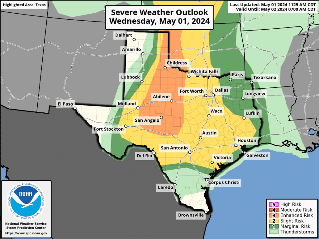
The Storm Prediction Center has placed our entire region, with the exception of Matagorda County, under a Slight Risk, or a 2 out of 5 risk, for severe thunderstorms through Wednesday night. Parts of the western and northern Hill Country have been placed under an Enhanced Risk, or a 3 out of 5 risk, for severe thunderstorms. (More on this particular area coming up).
Developing showers and storms are forecast to generally spread from south to north across the area this afternoon and evening.
Today’s rain and storms will also have the potential to produce heavy rain—especially if they slow down or happen to train over a particular area. A very moist, tropical air mass is in place. The heavy rains could possibly cause excessive runoff, resulting in flooding of creeks, streams, and other low-lying and flood-prone locations.
Due to the threat for heavy rain and possible flooding, the National Weather Service has posted a Flood Watch for the eastern Hill Country and all of Central Texas (including the Austin metro) from 3 pm Wednesday through 7 am Thursday.
Forecasters are also closely monitoring West Texas, where a large area of thunderstorms are forecast to develop late this afternoon along the dry line over the area between Midland and Del Rio. High-resolution forecasts call for the area of storms to organize into large complex strong to severe thunderstorms that will track east across the Concho Valley and western Hill Country between about 9 pm and midnight. The complex of storms is predicted to continue marching east across the Hill Country and into Central Texas between midnight and 6 am Thursday. This line of storms will also have the potential to produce large hail, damaging winds, considerable lightning, and heavy rain. The rain and storms are forecast to move off to the east by around or shortly after sunrise Thursday morning.
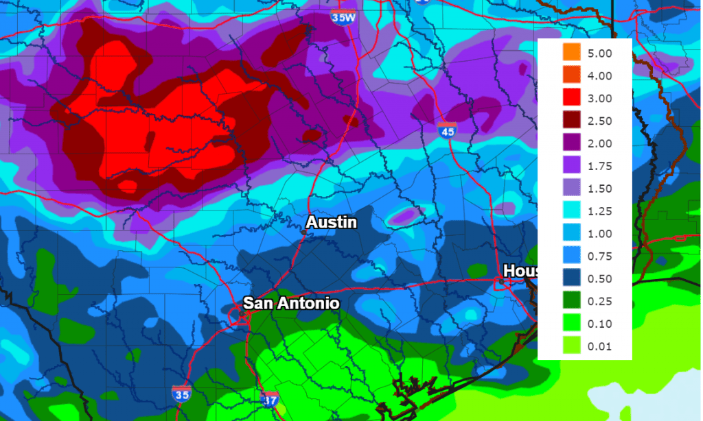
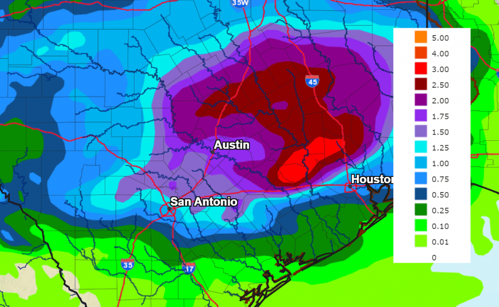
Rain totals this afternoon through Thursday morning are forecast call to generally average between 1 and 3 inches, with isolated totals to near 5 inches possible.
NWS Rainfall Forecast for the Period 7 am Wednesday through 7 am Thursday:
A break from the rain is forecast Thursday morning through Thursday afternoon. However, there will be a slight chance for additional showers and thunderstorms to spread into the Hill Country and parts of Central Texas Thursday evening.
Bob
Another Chance for Rain and Storms Forecast Wednesday, Continuing through the Weekend
Rain showers and thunderstorms spread across the Hill Country and the Interstate 35 corridor over the weekend. A few of the storms produced damaging winds and some small hail. Rainfall generally averaged around a half inch, with several isolated totals just over an inch. Southeast of Austin, totals between Bastrop and Bay City were considerably lower, averaging around a tenth of an inch or less. It’s interesting to note an area of heavy, persistent rain developed across the northern counties of Southeast Texas late Sunday night. Totals of 7 to near 12 inches of rain fell over the area between College Station, Huntsville, and Lake Livingston.
NWS Estimate of Rain Falling Between 7 am Friday and 7 am Monday:
Map Courtesy NOAA’s West Gulf River Forecast Center
A break from the wet and unsettled weather pattern is forecast to take place Monday afternoon through Tuesday evening as a weak ridge of high pressure temporarily sets up across Texas. Southeasterly breezes off the Gulf of Mexico are pulling a very moist air mass inland from the Gulf of Mexico, and this is leading to warm and very humid weather conditions. Expect a mostly sunny sky Monday afternoon. Low clouds look to spread across the area Monday night into Tuesday morning. In fact, some patchy will also be possible. The sky should become mostly sunny Tuesday afternoon.
- Monday’s temperature is predicted to reach the mid and upper 80s.
- Lows Tuesday morning are forecast to be in the mid and upper 60s.
- High temperatures Tuesday are forecast to be in the upper 80s to 90 degrees.
- Lows Wednesday morning are predicted to be around 70-72 degrees.
A chance for scattered afternoon and evening rain showers and thunderstorms will return to the forecast Wednesday when a small trough of low pressure is forecast to push east out of Far West Texas. This system is expected to cause thunderstorm development along the dry line across West Texas Wednesday afternoon. These developing thunderstorms are forecast to spread east across the Edwards Plateau and Hill Country regions late Wednesday afternoon through Wednesday evening. Some of these thunderstorms may be strong to severe, capable of producing large hail and damaging winds. The probability for rain and storms across the Hill Country will be near 40 percent late Wednesday afternoon and evening. At the same time, isolated to scattered rain showers and thunderstorms are also forecast to develop across Central Texas and the coastal plains region Wednesday afternoon and evening as the wave of low pressure moves over the area. The probability for rain will also be near 40 percent. Rain amounts Wednesday through Wednesday evening are predicted to average around a quarter inch or less. Wednesday’s temperature should climb to the low and mid-80s.
The most favorable period for rain showers and thunderstorms is expected to happen Thursday through Thursday night when a large trough of low pressure dips southeast into North Texas out of the southern Rockies. Forecasts call for an area of showers and thunderstorms to develop across the Concho Valley and Northwest Texas early Thursday afternoon. The area of rain and storms is expected to expand in coverage and intensity as it pushes east into Central Texas and the coastal plains regions late Thursday afternoon through Thursday night. Some of these storms may be strong to severe. The probability for rain will around 60-70 percent Thursday and Thursday night. The precipitation is forecast to exit to the east and southeast Friday morning as a cold front brings in drier and just slightly cooler air.
Rainfall forecasts through early Friday morning call for totals to generally average between 0.5 and 1 inch, with isolated totals to near 2 inches possible.
NWS Rainfall Forecast for the Period 7 pm Monday through 7 pm Friday:
Just a slight chance for rain is forecast Friday as the weak cold front pushes south into the Gulf of Mexico. Expect a partly cloudy sky with highs in the low 80s.
The outlook for the upcoming weekend calls for a partly cloudy sky and 30 percent chance for scattered afternoon and evening showers and thunderstorms both days. Rain amounts are forecast to average around a quarter inch. Warm and humid air looks to return in earnest this weekend. Expect high temperatures in the low and mid-80s, with lows in the upper 60s.
The outlook for next week calls for generally dry weather and noticeably warmer temperatures as a ridge of high pressure builds north across Texas. While a few showers can’t be ruled out, no widespread or heavy rain is anticipated. Daily high temperatures look to be around 90 degrees. Highs in the low 90s will be possible next Tuesday and Wednesday. Lows are forecast to be in the low 70s.
Bob
Rounds of Rain and Thunderstorms Forecast through Late Next Week
We are quickly moving into an active weather pattern that is expected to bring rounds of rain showers and thunderstorms to much of the Hill Country, Central Texas, and coastal regions for the next several days. Each of the periods of rain and thunderstorms will offer some potential for severe weather along with locally heavy rain. Forecasts are indicating this active pattern will last well into the month of May as more waves of low pressure approach from the west.
Friday
The first round of rain and thunderstorms developed early Friday morning across the Concho Valley ahead of a weak trough of low pressure that was pushing east out of West Texas. This area of thunderstorms tracked northeast across the northern Hill Country between Mason, Burnet, and Lampasas ands south to the Austin area Friday morning. There were radar indications the storms may have produced some large hail and strong winds between Burnet, Lampasas, and Temple. The storms are forecast to continue across this general area through mid-afternoon, then push northeast into East and Northeast Texas late Friday afternoon.
For Friday afternoon and Friday night, expect a mostly cloudy sky and breezy conditions. A fairly strong stable layer in lower atmosphere should limit the development of scattered shower and thunderstorm development. Forecasters will be closely watching for possible thunderstorm development mid to late afternoon along the Dry Line across the Big Country and northern Hill Country regions. The probability for thunderstorm development will only be 20 percent. However, any storms which develop will likely become severe. Expect southerly winds at 10-20 mph, with occasional gusts to 35 mph. Friday’s high temperature will be in the low 80s.
Saturday through Sunday
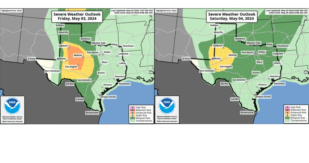
A moist and fairly unstable atmosphere is predicted to be in place across the region Saturday. However, a stable layer in the atmosphere is expected to limit thunderstorm development at most locations. Should a break in this stable layer develop, strong to severe thunderstorms will likely develop. The probability for rain and storms will only be near 20 percent. Morning clouds will give way to partly cloudy and windy conditions in the afternoon. Expect southerly winds at 15-25 mph, with gusts up to 40/45 mph. Saturday’s temperature is forecast to reach the low and mid-80s.
Confidence is quite high a large area of rain and thunderstorms will spread across the region Saturday night into Sunday morning as a strong wave of low pressure pushes east out of West Texas and New Mexico. Forecasts call for an area of thunderstorms to develop across western Texas Saturday evening, with the activity eventually merging into a broad line of showers and strong to severe thunderstorms around or after midnight. The rain and storms are predicted to spread east across the Hill Country after midnight Saturday night, moving into the Austin/Interstate 35 corridor around sunrise Sunday morning. The area of rain and storms should spread east across Central Texas and the middle Texas coast Sunday morning into Sunday afternoon. Some of storms may be severe. The Storm Prediction Center has placed the Hill Country under a Slight Risk, or 2 out of 5 risk, for severe thunderstorms through daybreak Sunday. The primary severe weather threats will be large hail and damaging winds.
The rain is expected to taper off across the Hill Country and I-35 corridor by Sunday afternoon, and across the rest of the region by Sunday evening. Lingering instability will cause a slight chance for a few spotty showers behind the main line. Rain amounts through Sunday evening are forecast to average around 1-1.5 inches across much of the area. Lower totals are forecast for areas south of Interstate 10.
Monday through Late Next Week
Periods of rain showers and scattered thunderstorms are forecast through late next week as additional small waves of low pressure move across Texas out of Mexico and the Desert Southwest. Some of these storms may be strong to severe.
Monday through Wednesday, the probability for rain looks to be around 30-40 percent. Rain amounts each day are predicted to average around a quarter inch. Forecasts point to an increased chance for rain and thunderstorms Thursday into Friday as a weak cold front pushes south into the area. As of now, widespread rain amounts of 1-1.5 inches are forecast. High temperatures next week are forecast to remain mostly in the low and mid-80s.
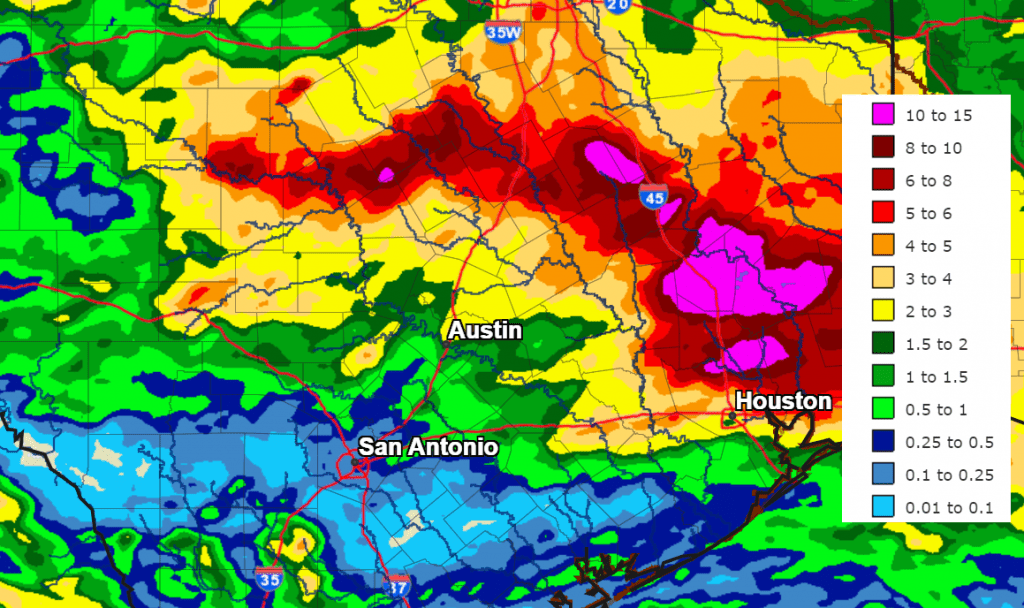
The National Weather Service’s total rainfall forecast for the next seven days indicates much of the area could see between 1 and 3 inches, with even higher totals possible across the northern Hill Country.
NWS Total Rain Forecast for Period through 7 pm Friday, May 3rd:
Looking out beyond late next week, forecasts show a chance for rain remaining in the forecast for the week of May 6th.
Bob
Warmer and More Humid Weather Returning. A Chance for Thunderstorms by Friday
Monday started off pleasantly cool, with temperatures in the 40s and low 50s. According to LCRA’s Hydromet, several spots around Brownwood recorded lows near 40 degrees. The Canadian air mass which allowed for the cooler readings this morning and over the weekend is unfortunately already on its was out. Southerly breezes have returned, meaning warmer and more humid air will soon be returning to the area.
Dry weather is forecast this afternoon through Thursday as a stable ridge of high pressure spreads over Texas out of Mexico and the Desert Southwest. At the surface, light southerly breezes are predicted for this afternoon and tonight. Wind speeds are forecast to increase to 10-15 mph, with gusts to 25 mph beginning Tuesday morning. The breezy conditions look to continue Tuesday night through Wednesday.
Expect a mostly sunny sky Monday afternoon. Low clouds look to develop across the eastern Hill Country and most of Central Texas after midnight Monday night continuing through Tuesday morning. The sky is forecast to become partly cloudy Tuesday afternoon. A similar pattern can be expected Tuesday night through Thursday.
- High temperatures Monday are forecast to be in the low 70s.
- Lows Tuesday morning are predicted to be in the low 50s across the Hill Country, and in the mid-50s at most other locations.
- High temperatures Tuesday are forecast to be near 78-80 degrees.
- Lows Wednesday morning will generally be in the mid-60s.
- High temperatures Wednesday and Thursday are forecast to be in the low and mid-80s.
- Lows Thursday morning will be near 68-70 degrees.
Some changes in the weather pattern are forecast to take place Friday and through the weekend as the ridge of high pressure over Texas weakens and shifts to the east. At the same time, forecasters will be closely monitoring a couple of waves of low pressure that are predicted to move from the southern Rockies to the central Plains. These two systems are forecast to bring a few rounds of rain showers and strong to severe thunderstorms to northern Texas and the Plains states Thursday through Sunday. Some of these storms could possibly extend south into the northern half of the Hill Country and Central Texas during this period.
Thursday’s weather is expected to be partly to mostly cloudy, breezy and warm as moisture increases off the Gulf of Mexico. Southerly winds will be gusting up to 30-35 mph. Expect a high temperature in the low 80s. Scattered thunderstorms are forecast to develop along the dry line across West Texas Thursday afternoon. There will be a 20 percent chance for a few of these storms to track east to parts of the northern half of the Hill Country late Thursday afternoon. Some of these storms could possibly be strong to severe.
Friday will see a slightly better chance for scattered thunderstorms across the Hill Country and most of Central Texas as the dry line shifts east to the eastern Hill Country. Forecasts call for scattered thunderstorms to develop across the area by afternoon. The probability for thunderstorms will be near 40-50 percent. Some of these storms could be strong to severe, with the primary severe weather threats being large hail and damaging winds. Rain amounts are predicted to average around a quarter inch. As of now, the thunderstorms are forecast to remain north of the coastal plains. Gusty winds look to continue. Friday’s temperature is forecast to reach the low 80s.
Another chance for scattered thunderstorms is forecast to take place Saturday through Sunday night as the second wave of low pressure drags a Pacific cold front east across the Hill Country and into Central Texas. The probability for rain is predicted to be near 30-40 percent. Once again, some of the storms could be strong to severe. Weekend rain amounts are predicted to average around a quarter inch. Expect a partly to mostly cloudy sky both days. High temperatures are forecast to be in the upper 80s, with lows only in the low 70s. The majority of the rain activity should stay north of the coastal plains region.
NWS 7-Day Rainfall Forecast Valid through 7 pm, Monday 4/29
Looking ahead to next week, forecast call for mostly sunny and dry weather Monday and Tuesday. A chance for scattered thunderstorm will return to the forecast Wednesday and continue through late week as a large trough of low pressure sets up across the western U.S., causing the dry line to become very active. Expect warm temperatures, with highs in the mid and upper 80s, and lows around 70 degrees.
Bob
Warm and Muggy through Late Week. A Good Chance for Rain this Weekend
Parts of the Hill Country and the Interstate 35 corridor have seen a few passing rain showers since Monday evening. The rain has been light, with totals averaging just a few hundredths of an inch. Meanwhile, little to no rain has fallen over the area located to the east of Interstate 35.
A trough of low pressure moving from the southern to the central Plains states has helped to push a Pacific cold front into the west central Texas. As of early Tuesday afternoon, the front stretched from Stephenville, to Llano, to near Del Rio. The front was separating a dry air mass to the west from a moist and very humid air mass to the east. Despite this change of air mass, the atmosphere overall is still fairly stable, so no significant rain or storms are forecast. The front has slowed its forward progress and is predicted to hold in its current position through Tuesday night. The front is then predicted to lift back to the north Wednesday morning.
For Tuesday afternoon and Tuesday night, expect a mostly cloudy to overcast sky for areas along and east of I-35. While a sprinkle or two will be possible, no significant rain is forecast. For most of the Hill Country, the sky will be mostly sunny Tuesday afternoon, then become mostly cloudy Tuesday night.
- High temperatures Tuesday afternoon will include the mid and upper 80s across the Hill Country, with low and mid-80s across Central Texas and the coastal plains.
- Lows Wednesday morning will range from the mid and upper 60s across the Hill Country, to the low 70s across the coastal plains.
Wednesday’s weather is shaping up to be mostly cloudy, warm, and humid. High temperatures are forecast to be around 90-92 degrees across the Hill Country, into the upper 80s across Central Texas, and in the mid-80s across the coastal plains. Lows Thursday morning are forecast to be near 70-72 degrees.
There will be 30 percent chance for scattered showers and thunderstorms for the Hill Country and Central Texas regions Thursday afternoon into Thursday evening as a couple of weak waves of low pressure push east out of West Texas. Scattered thunderstorms are forecast to develop Thursday afternoon along the dry line across West Texas and move to the east. There are indications some of these storms could be strong to severe. The Storm Prediction Center has placed the Hill Country and Central Texas regions under a Marginal Risk, or 1 out of 5 risk, for severe storms through Thursday night. The primary severe weather risk will be large hail. Spotty rain amounts to around a quarter inch will be possible.
- Thursday is predicted to be a warm day, with highs near 90-92 degrees across the Hill Country, near 90 degrees across Central Texas, and in the mid to upper 80s across the coastal plains.
Friday’s weather will feature morning clouds and a partly cloudy sky in the afternoon. There will be a 20 percent chance for a few scattered rain showers and thunderstorms across the Hill Country and Central Texas regions Friday afternoon. No rain is expected across the coastal region. Friday’s high temperature is forecast to be in the mid and upper 80s.
A wet and unsettled weather pattern is forecast Friday night and this weekend when a Canadian cold front slowly sags south across Texas and a trough of low pressure approaches from the west. Forecasts call for the front to move into the northern Hill Country late Friday afternoon, then stall in the area Friday night. The front is then forecast to get a push south into Central Texas Saturday afternoon and into the coastal region Saturday evening. Widespread overrunning showers and thunderstorms are forecast to develop across the northern Hill Country Friday evening and Friday night, with the activity shifting south with the front Saturday and Saturday night. The probability for rain will be near 80 percent. The rain should taper off from north to south late Saturday night into Sunday morning as the overrunning pattern diminishes. A mostly cloudy sky is predicted for Sunday afternoon.
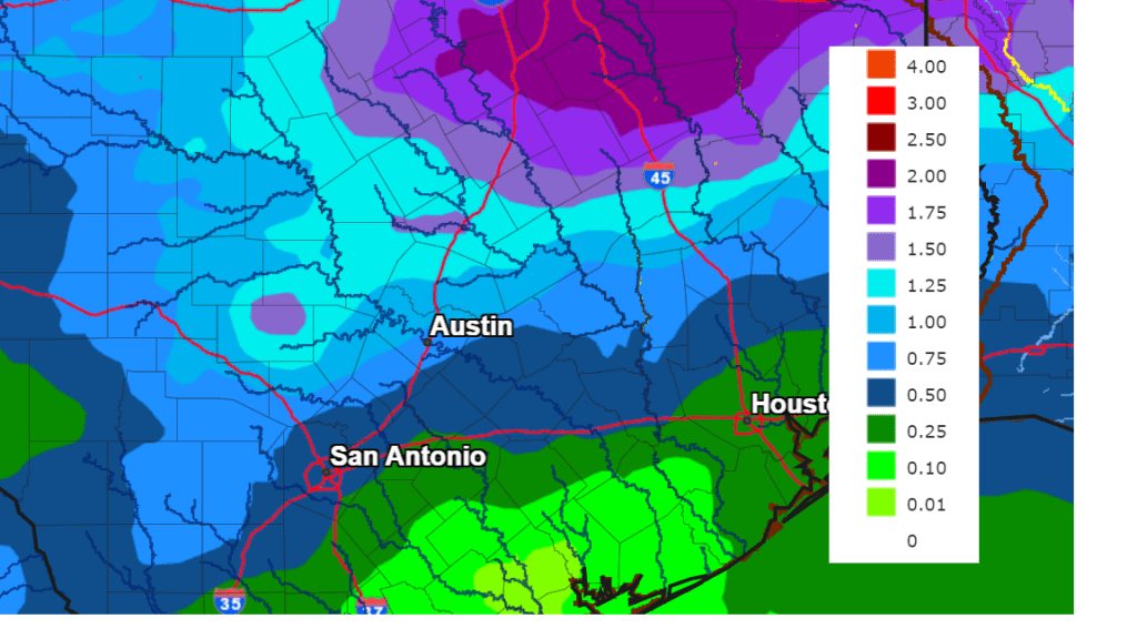
Forecasts call for the highest totals of rain to occur across the northern Hill Country and the northern counties of Central Texas where totals of 1-2 inches will be possible. Somewhat lower totals are forecast for the southern half of Central Texas and the coastal plains, where totals of 0.25 to 0.75 inches are forecast.
NWS Rainfall Forecast Valid through 7 pm Tuesday, April 23rd:
Much cooler air will arrive behind Saturday’s cold front.
- High temperatures Sunday will range from the mid-60s across the Hill Country, to the low 70s near the coast.
- High temperatures Monday are forecast to be in the mid-70s.
- Lows next Monday and Tuesday mornings will include the upper 40s across the Hill Country, the low 50s across Central Texas, and the mid-50s across the coastal plains.
Sunny weather is forecast through the first half of next week. Long-range solutions call for a chance for rain developing next Thursday and Friday. High temperatures are forecast to trend back to the mid and upper 80s for the second half of next week.
Bob
A Threat for Severe Thunderstorms Monday Afternoon and on Tuesday
While much focus in the short term will be on today’s solar eclipse (and rightfully so), full attention needs to be placed on an episode of potentially significant severe weather likely to affect Central Texas, the Hill Country, and the coastal Plains region beginning mid to late afternoon, continuing into tonight and again on Tuesday. It should be emphasized that only a short time period may exist between eclipse events and the initiation of strong to severe thunderstorms, so those with outdoor events may wish to encourage quick departures. The next 48 hours look to have the most favorable severe weather setup our area has seen so far this calendar year.
Weather Discussion
While the weather is predicted to stay dry through the eclipse window, changes are forecast to quickly take place by mid-afternoon as moisture increases ahead of an approaching trough of low pressure. High-resolution forecasts call for rain and thunderstorm to develop across the middle Texas coast by early afternoon, with the activity spreading north to parts of Central Texas and the eastern Hill Country during the mid and late afternoon. Forecasts call for the atmosphere to become increasingly unstable this afternoon, and could support the development of scattered strong to severe thunderstorms. Today’s primary severe weather threats will be large hail and dangerous cloud to ground lightning. There will also be a low-end threat for a couple of isolated tornadoes—mainly for areas north and northeast of Austin. The Strom Prediction Center has placed much of the area under a Slight Risk, or 2 out of 5 risk for severe thunderstorms through Monday night.
Most forecast solutions call for the thunderstorm activity to weaken early this evening, with a break from rain and storms expected late evening till just after midnight.
Forecasts call for the atmosphere across the region to become increasingly unstable beginning late tonight and toward daybreak Tuesday. Isolated to scattered thunderstorms are predicted to develop across the area during this time period. Showers and thunderstorms are then forecast to expand in areal coverage through the morning hours and into the afternoon. Several parameters will be in place that are expected to allow some of these storms to become strong and severe. The Storm Prediction Center has placed the Austin metro and much of Central Texas under an Enhanced Risk, or a 3 out of 5 risk, for severe thunderstorms. The rest of the region has been placed under a 2 out of 5 risk for severe thunderstorms.
While large hail, damaging winds, and dangerous lightning will be the primary severe weather threats, there will also be a secondary threat for isolated tornadoes—mainly in the Enhanced Risk area.
A lull in the precipitation is forecast to take place late Tuesday afternoon into Tuesday evening. However, another period of rain and thunderstorms is forecast to occur Tuesday night into Wednesday morning. Some of the storms may also be strong to severe. The rain activity is predicted to taper off by midday Wednesday as the trough to our west finally moves off to the northeast.
Do note, moderate to heavy rain will be possible from some of the storms both Monday afternoon and again on Tuesday. A few spots could see heavy downpours which could lead to some isolated flash flooding. In general, totals of 1-1.5 inches are forecast across much of the area through Wednesday morning.
Fingers crossed for some breaks in the clouds to persist for today’s eclipse!
Bob
A Pleasant Weekend Trending to an Increasing Chance for Rain Next Week
Here’s an update on weather conditions for Monday’s Total Eclipse, plus an outlook for next week. The weather pattern looks to be trending wet and quite active shortly after Monday’s eclipse.
Eclipse Day Weather Highlights
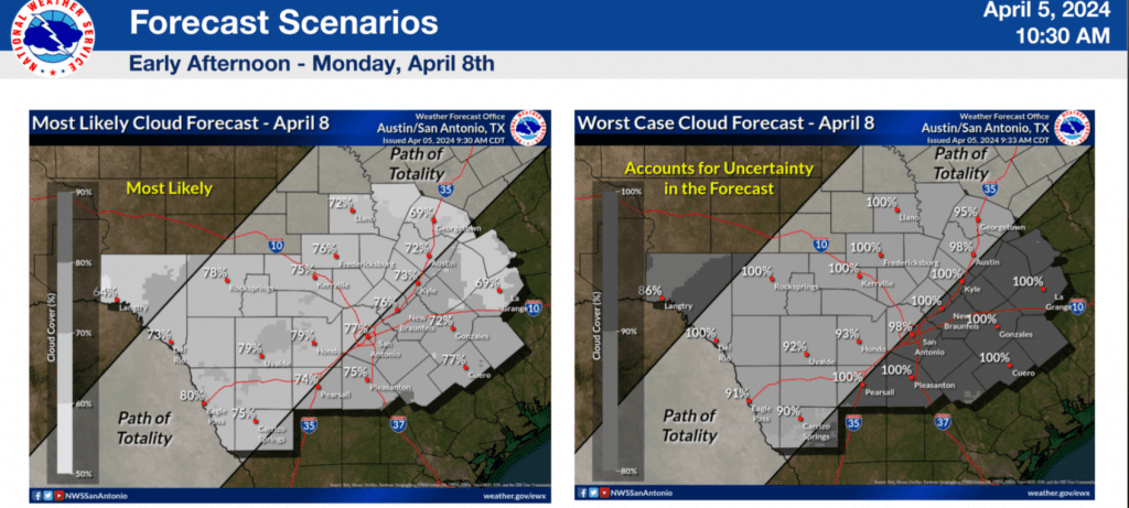
- The latest forecast solutions are showing little change in the weather outlook for Monday. Forecasts continue to call for a mostly cloudy sky across the region through the midday hours on Monday.
- While some breaks in the low-level clouds will be possible, considerable high-level clouds are still forecast to be in place, creating less than ideal conditions for viewing the eclipse.
- Some fluctuation in the forecast will still be possible over the next couple of days, but chances for optimal sky conditions to view the eclipse will be less than 10 percent.
Forecasts continue to call for a trough of low pressure to move into the Southwestern U.S. late Sunday into Monday. Out ahead of the trough, southerly winds off the Gulf of Mexico are predicted to increase beginning Sunday evening, causing a surge of moisture and low, dense clouds into Central Texas and the Hill Country. While a few small breaks in the low clouds will be possible by midday Monday, forecasts continue to call for a considerable high-level clouds to also blanket the sky. Unfortunately, even these high clouds are predicted to be somewhat thick and unfavorable for getting a good view of the eclipsed sun.
Any breaks in the clouds that might happen to develop midday will be short-lived. Forecasts call for clouds to quickly thicken up by mid-afternoon. There will be a 50 percent chance scattered rain showers and thunderstorms across the region after about 3 pm. Some of these storms may even be strong to severe.
The National Weather Service’s cloud forecast for early Monday afternoon calls for at least 75 percent cloud coverage across the area in its most likely scenario:
Weather Discussion for the Weekend and Next Week
Sunny and breezy weather will be in place Friday afternoon. Expect southerly winds at 10-15 mph, with occasional gusts to 25 mph Friday afternoon through Friday night. High temperatures are forecast to be in the low and mid-80s. Lows Saturday morning will be in the upper 50s to low 60s.
On Saturday, a trough of low pressure is forecast to lift northeast from New Mexico up to the Central Plains, dragging a Pacific cold front into the state. Forecasts call for the front to reach the western Hill Country Saturday evening, moving across Central Texas Saturday night. The front is predicted to stall just east of Interstate 35 Sunday morning, then move back to the north as a warm front Saturday night. With limited moisture in place, no rain is forecast with the front.
Saturday’s weather will include widespread morning clouds, followed by a partly cloudy sky in the afternoon. It will be another breezy and warm day. Expect southerly winds at 10-20 mph, with occasional gusts to 30 mph through Saturday evening. Wind speeds should decrease after midnight Saturday night. The sky is predicted to be sunny to partly cloudy on Sunday.
- High temperatures Saturday are forecast to be near 80 degrees.
- Lows Sunday morning will include the low 50s across the Hill Country, the upper 50s to low 60s across Central Texas, and the low 60s across the coastal plains.
- High temperatures Sunday are forecast to be in the low 80s.
- Lows Monday morning will include the mid and upper 50s across the Hill Country, the upper 50s to low 60s across Central Texas, and the mid-60s across the coastal plains.
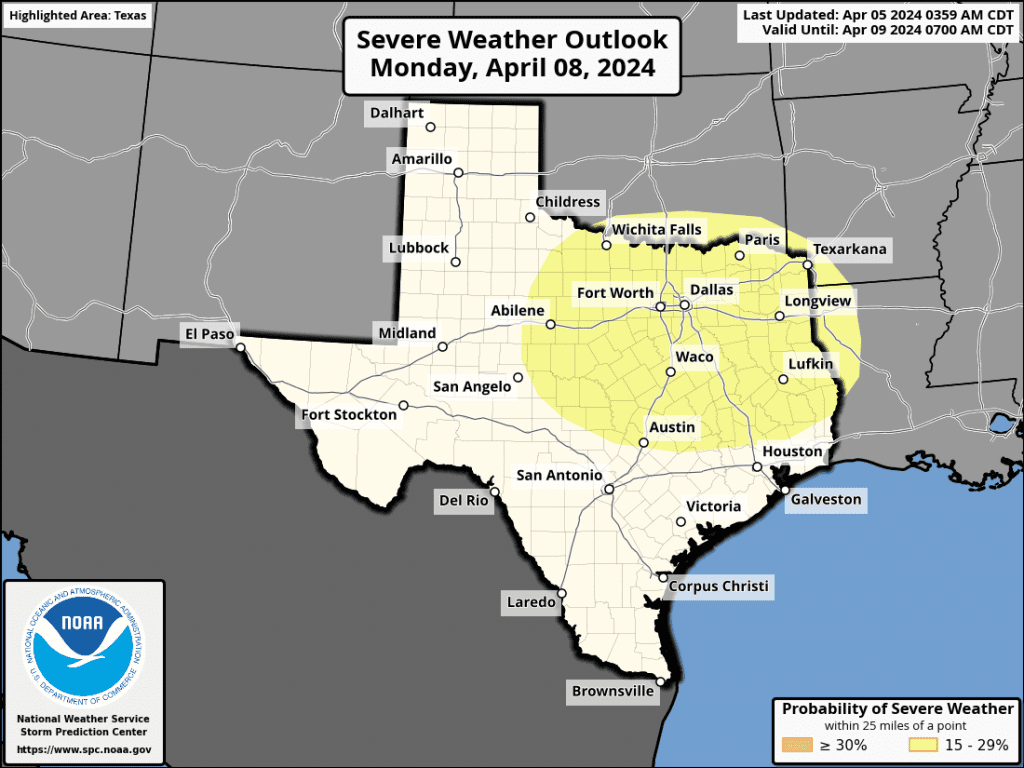
A large trough of low pressure is predicted to move into the Southwestern U.S. late Sunday and become nearly stationary. As mentioned in the eclipse discussion, flow out ahead of the trough is expected cause a surge of clouds and moisture north into Central Texas and the Hill Country beginning Sunday night, continuing throughout the day on Monday. As moisture levels increase Monday afternoon, an expansive area of light rain showers and scattered thunderstorms is forecast to develop across the region and continue through Monday night. The probability for rain will be around 50 percent. There are early indications some of the developing thunderstorms could be strong to severe. Rain amounts up to a quarter inch are forecast. The Storm Prediction Center is highlighting the northeastern Hill Country and the northern counties of Central Texas, including Austin, for the possibility of severe storms:
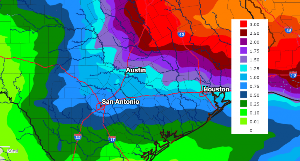
There will be an increased chance for periods of rain showers and scattered thunderstorms across the entire region Tuesday through Wednesday as the southwestern trough slowly wobbles east into West Texas. The combination of the slow-moving trough and a very moist flow off the Gulf of Mexico is expected to result in multiple rounds of rain showers and thunderstorms Tuesday through Wednesday. Moderate to occasionally heavy rain is forecast. The rain is forecast to linger into Thursday morning, then wrap up Thursday afternoon as the upper trough finally moves off to the Mississippi Valley.
There will be a potential for significant amounts of rain. The latest National Weather Service’s forecast calls for widespread totals of 1-2 inches, with isolated higher totals possible.
NWS Rainfall Forecast Valid through 7 pm Next Friday:
Dry and breezy weather is forecast for next Thursday afternoon and Friday. Sunny weather looks to continue into next weekend as well. Expect high temperatures in the 70s, with lows in the 50s.
Colorado State University Hurricane Outlook Was Released Thursday
Dr. Phil Klotzbach and Colorado State University released their outlook for the upcoming hurricane season on Thursday, and it is expected to be an extremely active season!!! The outlook calls for 23 named storms, 11 of them hurricanes, and 5 major hurricanes. Klotzbach stated this is most active forecast he has ever made. The combination of unusually warm sea surface temperatures across the Atlantic and a switch to La Nina by the heart of the season were behind the high numbers forecast.
Bob
Social Media